Showing posts with label ghost town. Show all posts

Monday, July 31, 2017

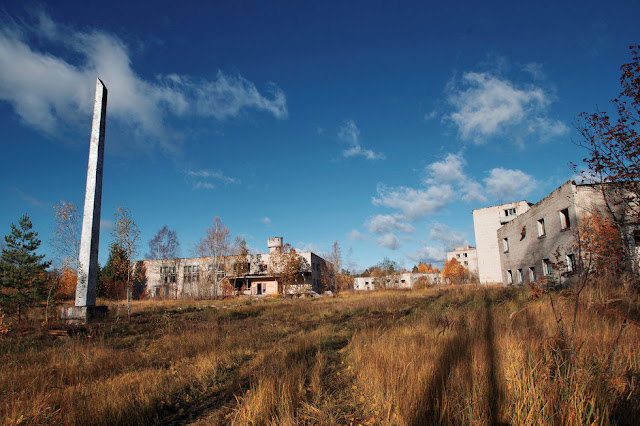
An abandoned Soviet village in Siberia

This village was founded in 1968 on the shore of the Anadyr Bay of the Bering Sea, opposite to the town of Anadyr. You wouldn't find it on the map during the Soviet era, as part of the village was a military settlement guarding the eastern borders of the USSR, opposite to Alaska. Those living in the civilian part of the village were mainly engaged in lignite mining. 

After the fall of USSR and the elimination of a part of the country's nuclear weapons, the military part of the village was abandoned. The officers' club, a school and a shopping center were shut down. That was the beginning of the end for the village. In 2013, the local authorities decided to move the last remaining residents to Pervomaysky district as 70% of the village was abandoned by then.

Russian photographer and blogger e-strannik visited the village in 2016, capturing what was left behind by the last residents of a village that you again won't find on a map. 


Monday, June 19, 2017

The ruins of a Chinese city, turned into a museum after the Great Sichuan Earthquake


On May 12th, 2008, a magnitude 8.0 earthquake hit a mountainous region in southwestern Sichuan province of China. Over 70,000 people lost their lives while hundreds of thousands were injured and 5 million remained homeless. 

In Beichuan county 3,000 to 5,000 people were killed and 80% of buildings were destroyed. Qushan Town which was until then Beichuan's county seat was abandoned but instead of pulling them town, authorities decided to stabilize and preserve the ruins as part of the Beichuan Earthquake Museum. There were hydraulic engineering projects to help preserve the site and an underground museum was built at the site of of the old Beichuan High School. 

The Earthquake Museum site also includes Tangjiashan Lake which was formed during the earthquake.  


Monday, April 24, 2017

The Italian ghost town of Balestrino


Situated in Liguria, 70 kilometres (43 mi) southwest of Genoa, Balestrino is one of Italy's most mysterious ghost towns, with little information known about the town's history and origins as well as its demise. 

Balestrino dates back to at least the 11th century. During the middle ages, the Bava family, nobles from Piedmont, were the feudal lords of the town and the one's who built Balestrino's oldest castle. Later, in the 16th century, the Del Carretto family came into power and built their castle. The castle was burned down and the lord was killed in 1561, leading the family to establish a court and torture chambers to maintain control and stop rioting. 

Although the town managed to flourish, battles between his armies and locals during the occupation of Napoleon severely affected the area and its population. Balestrino came under the rule of the Kingdom of Sardinia and Piedmont and in 1860 it became part of the Kingdom of Italy

It is believed that earthquakes and hydrogeological instability was the main reason for the town's demise. A number of earthquakes in the 19th century caused a part of the population to flee, with the last inhabitants evacuating Balestrino in 1953. 

The abandoned area is 1.5 hectares wide and is made up of fascinating buildings such as the churches of St. George and St. Andrew, built in twelfth century. The town's best-preserved building is the Byzantine castle of Del Carretto, while the bridge of Deautra, covered in wild plants, is another beautiful corner of the abandoned town. 

Today, the ghost town of Balestrino, situated close to the newer Balestrino town is visited by thousands of visitors and explorers every year. It has also caught Hollywood's attention, chosen as a location for the movie Inkheart.


For more deserted places, LIKE US on Facebook and FOLLOW US on twitter


Monday, March 27, 2017

The Scottish ghost village of Polphail

During the 1970's the UK government was looking for locations on the Scotland coast where it could construct sites to build oil platforms, based on forecasts for future demand. Polphail, on the west coast of the Cowal Peninsula, in Argyll & Bute was one of the locations chosen, as it provided a sheltered port where a a dry dock and a construction yard could be built. Land was purchased by the government and a village that could house up to 500 workers was built between 1975 and 1977. 

However, the village of Polphail was never inhabited. Structural design issues of the oil gravity platforms, cost implications and inflexibility in the sector at the time led to no orders being placed at the yard. Polphail was now a ghost village. In 2009 it gained some publicity as an artistic collective visited the empty streets of Polphail to create a graffiti art gallery with paintings of figures, faces, abstract designs and haunting images, before all structures are demolished.


Monday, January 9, 2017

The ghost town of Ellaville in Florida


The town of Ellaville was founded in 1861 by businessman and future governor of Florida George Franklin Drew. Drew built a mansion on the western banks of the Suwannee River in Suwannee County. He named the town 'Ellaville' to honor Ella, his long-time African American servant. 

After the Civil War, Drew and his partner Louis Bucki opened a steam-operated sawmill. The mill soon became the largest in Florida, employing more than 500 people. Florida Railroad built a line to the town that had direct access to the mill and soon after, Ellaville was blooming. In the early 1870s the town had a train station, two schools, two churches, a steamboat dock, a masonic lodge, a commissary and a sawmill.

By then, George Drew had become one of the richest men in Florida, being elected governor in 1876. After his term, he sold his company share to the Bucki and he moved to Jacksonville. The mill was burned down in 1898 and although it was soon rebuilt, there was no longer a significant number of pine still left to harvest. Extensive floods during the 1900's and later the onset of the Great Depression attributed to the decline of Ellaville. The post office finally closed in 1942 and soon the town vanished. 

Little remains of Ellaville exist today. The Drew mansion, which had been vandalized over the years finally burned down during the 1970's. In 1986, the Hillman Bridge built in 1925 by the Federal Aid Project was abandoned and replaced by a new bridge across the river.


SEE ALSO: More ghost towns around the world // More abandoned places in Florida // More abandoned places in the United States // LIST OF ALL DESERTED PLACES 
For more deserted places, LIKE US on Facebook and FOLLOW US on twitter


(Click here for the full post)


Monday, November 28, 2016

Inside the abandoned villages of Hong Kong

Just outside central Hong Kong, in the vast area known as New Territories, many once-thriving villages, have now been left abandoned and overtaken by nature. Many of these remote settlements were flourishing until the 1950s. Then, people started to move to the urban areas to find better-paid jobs, while others took advantage of Hong Kong's ties to the UK and went oversees to work in the Chinese restaurant business. 

By the 1960's an increasing number of people moved away from these villages, abandoning the rural homes, and traditional lifestyles like farming and fishing became less viable. Today, houses and other buildings in villages such as Chau Tau and Sham Chung have been consumed by Hong Kong's climate and fast-growing foliage. Even though some former residents would like to return to their villages, it's hard to so as the government doesn't offer enough services in those rural areas. Today, the only ones who visit Hong Kong's abandoned villages are hikers and urban explorers. 


SEE ALSO: More ghost towns around the world // More abandoned places in Hong Kong // LIST OF ALL DESERTED PLACES 
For more deserted places, LIKE US on Facebook and FOLLOW US on twitter


(Click here for the full post)


Monday, October 31, 2016

Skrunda-1: A Soviet ghost town in Latvia


The town of Skrunda-1 in modern day Latvia was of strategic importance to the Soviet Union. It was where two Dnepr radar installations were constructed in the 1960s. The two giant radars, having a length of 244 metres (801 ft) and height of 20 metres (66 ft) each, were one of the most important Soviet early warning radar stations for listening to objects in space and for tracking possible incoming intercontinental ballistic missiles.

The town was comprised by 60 buildings, including apartment blocks, a school, barracks and an officers club. After the collapse of the Soviet Union, with an agreement signed in 1994, Latvia allowed the Russian Federation to continue running the radar station for 4 more years, after which it was obliged to dismantle the station within eighteen months. Before vacating Skrunda-1 in 1998, the Russian troops dismantled the site and all material of value were carried to Russia. Since then, Skrunda-1 is a ghost town.

In 2008, the Latvian government decided to sell the Skrunda-1 site and in 2010, the entire 40-hectare (99-acre) former town was sold as a single lot at auction in Riga. The winning bid was by a Russian firm for 3.1 million USD (2.2 million EUR). However, the winner as well as the runner up pulled out of the auction. In 2015, the site was bought by Skrunda Municipality for just €12,000 ($13,450). Half the area was handed over to the Latvian National Armed Forces as a training ground while the remainder is to be leased by the local government to potential investors for development. 

As of February 2016, due to increased interest at the site, the municipality began charging an entrance fee of 4 euros to individuals.


SEE ALSO: More abandoned ghost towns around the world // More abandoned military facilities // LIST OF ALL DESERTED PLACES 
For more deserted places, LIKE US on Facebook and FOLLOW US on twitter


(Click here for the full post)


Monday, October 24, 2016

The ghost town of Rhyolite, Nevada


Rhyolite, Nevada has been called "the most photographed ghost town in the West". Built in 1905, in the edge of Death Valley, 120 miles (190 km) northwest of Las Vegas, Rhyolite was one of several mining camps that sprang up during gold rush.

Starting as a two-man camp in January 1905, Rhyolite became a town of 1,200 people in two weeks and reached a population of 2,500 by June 1905. By then it had 50 saloons, 35 gambling tables, cribs for prostitution, 19 lodging houses, 16 restaurants, half a dozen barbers, a public bath house, and a weekly newspaper, the Rhyolite Herald. Industrialist Charles M. Schwab bought the Montgomery Shoshone Mine in 1906 and invested heavily in infrastructure, including piped water, electric lines and railroad.

Rhyolite in 1907 had concrete sidewalks, electric lights, water mains, telephone and telegraph lines, daily and weekly newspapers, a monthly magazine, police and fire departments, a hospital, school, train station and railway depot, at least three banks, a stock exchange, an opera house, a public swimming pool and two formal church buildings. By 1908, Rhyolite had a population of 5,000.

Rhyolite's decline was as fast as its rise. Production in the mine fell quickly as soon as the richest ore was exhausted. Moreover, the 1906 San Francisco earthquake and the financial panic of 1907 made it more difficult to raise development capital and soon the company's stock value crashed. In 1911 the mine closed after operating at a loss for a few years. By then, most workers had already moved elsewhere and the town's population was below 1,000. By 1920, it was close to 0.

This is when Rhyolite started becoming an attraction as a "ghost town". The town was used as a backdrop for movies even since the silent film era, starting with The Air Mail in 1925. Other movies that followed were The Reward (1965), Cherry 2000 (1987), Six-String Samurai (1998) and The Island (2004).


SEE ALSO: More ghost towns around the world // More abandoned places in Nevada // More abandoned places in the United States // LIST OF ALL DESERTED PLACES 
For more deserted places, LIKE US on Facebook and FOLLOW US on twitter


(Click here for the full post)


Tuesday, October 4, 2016

The urban ruins of Cairo, Illinois

The town of Cairo, Illinois was established in 1836 in the heart of "Little Egypt". That's where the Mississippi and Ohio Rivers converge, in an area with the lowest elevation of any location within Illinois. In 1855, Cairo became the terminus of Illinois Central Railroad and the town flourished as trade with Chicago spurred development. By 1860, the population exceeded 2,000.

During the American Civil War, Cairo became a strategically important supply base and training center for the Union army, even though much of the city's trade was diverted to Chicago. However, due to Cairo's strategic location, the town flourished after the War. It became a center for banking and an important steamboat port, with so much river traffic that the city had been designated as a port of delivery by act of Congress in 1854. Moreover, Cairo became a hub for railroad shipping in the region. Wealthy merchants and shippers were attracted to Cairo, building numerous fine mansions in the 19th and early 20th century.

The peak of Cairo's population came in the 1920's, surpassing 15,000 people. Ferry traffic had already started declining as the railroad was now able to cross the river after new bridges were constructed. Cairo was no longer an important hub. 

With river traffic and rail traffic drastically reduced, much of Cairo's shipping, railroad, and ferry industries left the city and employment prospects were gone with it. Racial tension was strained by the late 1960s as the United States was in the middle of the civil rights struggle. Racial violence, protests, and riots between police and Cairo's black community intensified the city's decline. In 1978, with the opening of a new Interstate 57 bridge across the Mississippi River Cairo was bypassed and the town was now crippled. Restaurant and hotel businesses, and even Cairo's hospital closed.  

By 2010, Cairo had only 2,831 people. Poverty, crime and unemployment still remain a challenge for the town. In the recent years there have been attempts to restore some of Cairo's abandoned buildings to develop heritage tourism focusing on its history and relationship to the Mississippi and Ohio Rivers.


SEE ALSO: More ghost towns around the world // More abandoned places in the United States // LIST OF ALL DESERTED PLACES
For more deserted places, LIKE US on Facebook and FOLLOW US on twitter


(Click here for the full post)


Monday, August 15, 2016

The abandoned fortified town of Ait-Ben-Haddou in Morocco


The town of Ait-Ben-Haddou was founded along the former caravan route between the Sahara and Marrakesh in present-day Morocco. The fortified town dates from the 17th century and it's an example of earthen clay architecture, which is also used in Moroccan architecture

Ait-Ben-Haddou's giant fortification is made up of six forts (Kasbahs) and nearly fifty palaces which are individual forts. The town contains a mosque, two cemeteries (Jewish and Muslim) and a public square. Most reports mention that only 2-8 families live in the ancient city today while most of the population live in a nearby modern village.

Ait-Ben-Haddou has been a UNESCO World Heritage Site since 1987. Several films and tv series have been shot there including Oedipus Rex, Jesus of Nazareth, The Jewel of the Nile, The Last Temptation of Christ, Gladiator, Babel, Prince of Persia, and Game of Thrones.

* Ait-Ben-Haddou has also been transliterated in English as Aït Benhaddou, Ait Benhaddou, Aït-Ben-Haddou, Ath Benhadu. 


SEE ALSO: More ghost towns around the world // More abandoned places in the desert // LIST OF ALL DESERTED PLACES 
For more deserted places, LIKE US on Facebook and FOLLOW US on twitter


(Click here for the full post)